

Stand at 8,000 feet and your body knows it before your brain does, heart hammering, lungs working harder than usual, clouds literally passing through stone doorways in front of you. That’s Machu Picchu before you’ve even had a chance to process what you’re looking at. Wedged between two Andean peaks in a way that genuinely shouldn’t work, the place has spent decades being reduced to a pretty picture in travel magazines. The actual history is messier, and honestly, more interesting.
The “lost Inca city” label has always been a bit generous. Hiram Bingham showed up in 1911 ready to make history, and he did, just not quite the way the story usually gets told. There were already farmers living on those ancient terraces when he arrived, doing what people in that area had apparently never stopped doing. The Spanish never found it, sure, but the Andean communities around it knew exactly where it was. “Lost” mostly meant lost to everyone else.
As for what it actually was, probably not a fortress. Most researchers point to it being a private royal estate built for the emperor Pachacuti, doubling as a religious site. Sitting that high up in the mountains turned out to be a quiet kind of protection. The Conquistadors tore through plenty of Inca cities, but this one they simply never reached, which is a big part of why it still looks the way it does today.
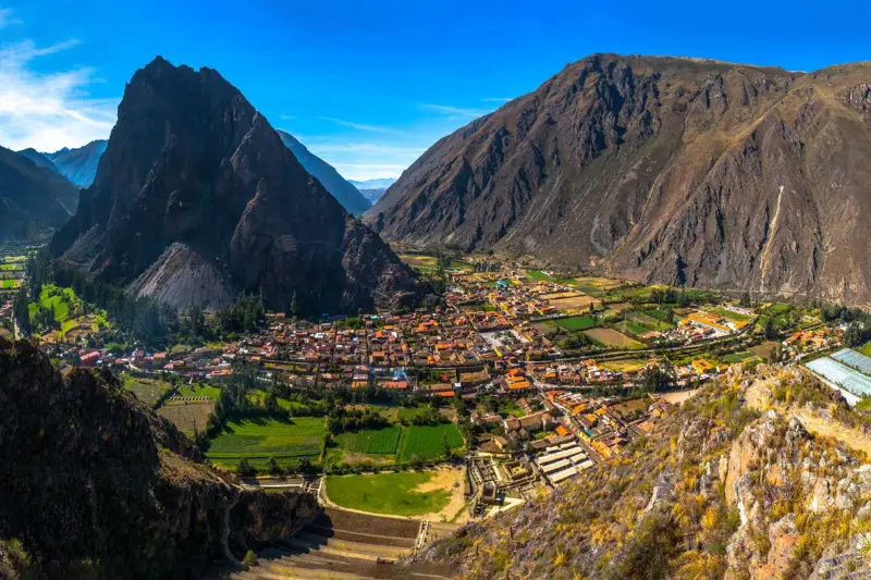
Cusco was the center of everything, literally. The Inca had a name for it that translated roughly to navel of the world, and that wasn’t ego talking, it was geography and politics wrapped into one. The city carried the weight of the empire spiritually and administratively, but it didn’t feed itself. That job fell to the Sacred Valley, the stretch of land running alongside it that happened to be some of the most workable soil at that altitude anywhere in the region. Emperors claimed pieces of it for their own estates. Farmers worked it for corn and potatoes. The mountains surrounding it made sure nobody came through uninvited.
The Urubamba River cuts through the whole thing, loud and cold and not particularly interested in slowing down for anyone. It wraps around the base of Machu Picchu mountain in a way that, once you see it on a map, makes the site selection feel almost obvious. Running water nearby meant survival. The canyon dropping off on all sides meant enemies had a bad time getting close. The famous views people photograph today were never really the selling point, the landscape was doing a job.
Keeping that landscape connected took something extraordinary. Over 25,000 miles of stone road, no wheels involved, no horses pulling carts, nothing that would make sense by conventional logic. The Qhapaq Ñan just existed, running from coastal lowlands up to passes where the air gets thin enough to hurt. Trained runners worked those paths in relay, moving information and goods across elevations that would wreck most people. Machu Picchu being tucked away in the mountains didn’t isolate it, those roads made sure of that.
Then came the part that still confuses engineers today. After solving transportation across impossible terrain, someone decided to build a heavy stone city directly on a fault line sitting between two peaks. The rock was already there on the mountain, that part was convenient. Actually cutting it, moving it, fitting it together tightly enough to survive earthquakes for centuries, that’s the part nobody has fully figured out how they pulled off.
Mortar made sense in Europe. The ground there cooperates. You stack bricks, you bind them, the wall stands. Take that same logic to the Andes and eventually the earth reminds you why it was a bad idea. Tremors in that region aren’t occasional inconveniences, they’re routine, and anyone building something meant to last had to account for them. Inca engineers did. They developed Ashlar masonry, which sounds technical but the principle is straightforward: cut the stone accurately enough and it holds itself together. No mortar, no glue, nothing. The blocks fit so cleanly that a credit card won’t go between them. When a quake hits, the wall moves with it instead of against it, then finds its way back. Rigid things break. These didn’t.
You can see the difference without looking very hard. All across the region, colonial buildings that Spanish settlers put up using their familiar rectangular frames cracked and fell during major earthquakes. The Inca stonework underneath those same buildings stayed put. Some of it comes down to the shape of an opening. Inca doors and windows are trapezoidal, thicker at the base, narrowing toward the top. Most visitors walk through them without giving it a second thought. But that shape handles seismic stress differently than a square frame does, spreading the load rather than concentrating it at the corners. Simple geometry doing serious structural work.
Then there’s the question of the mountain itself. All that green terracing people photograph looks agricultural and some of it was, but treating it purely as farmland undersells what was actually built there. Dig past the topsoil and you find a deliberate layering system: large rocks first, then gravel, then sand, each layer moving rainwater downward and outward before it can pool and destabilize the slope. That mountain gets hammered with rainfall. Without a drainage system engineered into the hillside itself, none of the structures above it would have survived long. The terraces weren’t decoration sitting below the city. They were part of what kept the city standing.
And it’s still standing. That fact tends to get glossed over in favor of the views and the history, but it’s probably the most remarkable thing about the place. The empire is gone. The people who designed and cut those stones left nothing written down explaining how they did it. Centuries of rain and seismic activity have come and gone. The granite is still there, largely as it was, outlasting everything that was supposed to be more advanced than it.

The engineering answers one question and immediately raises another. Keeping a mountain stable is a problem with technical solutions. Deciding to build on that specific mountain, at that altitude, traces back to one person. Pachacuti didn’t inherit an empire, he built one, taking Cusco from a regional kingdom and expanding it outward in the mid-1400s until it covered more ground than most rulers ever see. The site he commissioned wasn’t meant for war. It was personal, closer to a private retreat than a military installation, a place to escape Cusco’s brutal winters, host the people worth impressing, and exist inside a setting that did some of the talking for him.
Understanding the scale requires knowing how Inca rulers handled death and property. When an emperor died, whoever replaced him got the throne and essentially nothing else. No wealth, no estates, nothing accumulated. All of that stayed with the Panaka, the group of descendants responsible for maintaining what the dead ruler left behind, including his mummified body, treated as a presence still worth attending to. The next emperor started from zero, which meant conquest was the only path to building anything personal. Sites like this one stayed frozen in time as a result, belonging to Pachacuti’s lineage, never absorbed into anything communal.
There was still a third layer to what the place was. The layout makes it visible. Residential areas on one side, agricultural terracing on another, and then the highest ground given entirely to temples for Inti, the Sun God. Pachacuti seems to have thought of the estate as something operating between worlds, a location where the distance between human life and whatever sat above it felt shorter. It didn’t protect the place from what came next. Chaos moved through the Andes anyway, and the estate eventually went quiet for a very long time.
Nobody fired a shot to start the end of this place. Smallpox got there first, running ahead of the Spanish down through the continent before any soldier knew the terrain. Huayna Capac caught it and died, and that death pulled the thread that unraveled everything. Two of his sons went to war over what he left behind, and an empire fighting itself from the inside can’t keep a remote mountain estate running. That kind of place only works when the capital is stable and the supply chains hold. Neither was true anymore.
The site emptied out within a century of being built, and it happened the way most collapses do, not all at once but in pieces:

Something else gets mixed up regularly when people talk about this period. The Spanish weren’t looking for Machu Picchu. They wanted Vilcabamba, the actual final capital of the empire, and they found it eventually and burned it. Pachacuti’s estate never came up because it wasn’t a military target. The locals who knew its location kept that to themselves, and the Spanish had no particular reason to go looking for a private retreat they didn’t know existed.
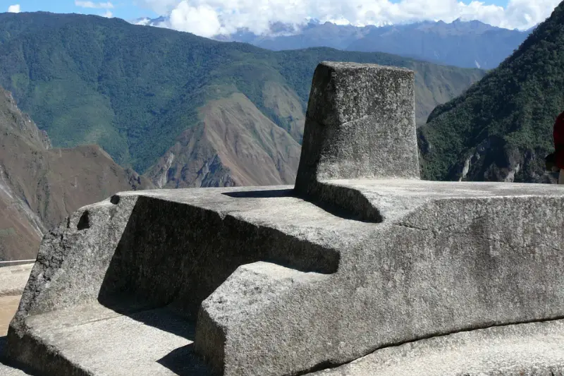
On the way out, the Inca pulled down the bridges and stopped maintaining the jungle trails that led there. Vegetation moved back in fast. That overgrowth turned out to be the best protection the site ever had. No Spanish soldiers meant no religious purging, which meant the objects inside stayed untouched. The Intihuatana Stone is still there because of that, a ceremonial object that survived centuries it probably shouldn’t have, simply because the jungle swallowed the road leading to it.
There’s a carved granite pillar at the highest point of the city called Intihuatana that looks abstract until you understand what it was built for. It tracks the sun. Not roughly but with real precision, enough to call the solstices accurately. The equinoxes are the most striking part, when the sun reaches a specific position above it the pillar throws no shadow at all. Farmers and engineers read that moment as a practical signal. There was no written calendar. That pillar was the calendar.
The name people use for it translates somewhere close to Hitching Post of the Sun, and that translation actually explains the thinking behind it pretty well. The Inca didn’t treat the sun as something permanent and reliable. Winter solstice meant the sun was at risk of drifting off and not returning, and something had to hold it in place. This stone did that job. It fell into a category called Huaca, which covered objects and locations thought to hold living energy inside them rather than just occupy space. Sacred doesn’t quite cover it. People did not see the stone as a symbol of something holy; they considered it an active presence.
That same logic ran through the rest of the construction. The builders did not position the walls and windows across the site for aesthetics or convenience. Instead, they aligned specific openings to frame certain stars or capture particular mountain peaks at meaningful moments, turning the architecture itself into a tool for reading the sky. The priests who used it weren’t working in a beautiful backdrop, the buildings were feeding them information. Those paths they walked are still there today, which connects directly to what draws people to the Inca Trail and the route toward Choquequirao as two separate ways of covering that same ground.
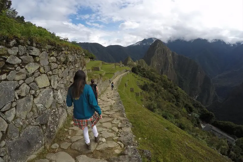
Two options exist for anyone walking through this history and they don’t have much in common. The Inca Trail is the known quantity, busy, documented, ends at the ruins around sunrise if things go smoothly. Choquequirao goes the other direction, a multi-day physical commitment through terrain that doesn’t apologize, with almost nobody else around. What you give up in comfort comes back as silence.
Logistics tend to decide things before most people even start packing. Travelers need to book Inca Trail permits up to six months in advance, and conservation rules have significantly reduced access. Choquequirao runs looser on regulations for now, but there’s no train or bus waiting at the finish. You walk back out the same way you came in.
Either way, altitude plays no favorites. Above 11,000 feet a short flight of stairs becomes something your lungs notice. Soroche doesn’t care if you run marathons or haven’t exercised in months, it shows up on its own schedule. Managing it is as important as anything else you pack:
Getting yourself up there is one problem. What happens to the stones when thousands of people do it every single day is a different problem, and one that’s getting harder to ignore.
A photo doesn’t capture what these ruins actually are. Someone figured out how to cut granite without iron tools, on a fault line, at cloud level, and what they built is still standing. The narrative around the place has slowly stopped treating it like an abandoned mystery and started giving credit where it was due, to people who knew exactly what they were doing and whose descendants never went anywhere.
That shift in understanding should follow you there if you go. The trail isn’t something you conquer, the site isn’t something you check off. Guides with genuine roots in Quechua culture exist and are worth finding specifically, the kind of visit that puts money into local communities rather than around them. Marked paths feel like a minor ask until you consider that the walls holding up around them have outlasted empires and are now contending with daily foot traffic from thousands of strangers.
Those terraces people photograph have farmers working land in the valleys below them right now. Treating the site as a historical artifact sealed off from the present gets it wrong. The thread between the people who cut those stones and the people living in that region today never broke. That connection is the thing worth being careful with.

 Tripadvisor